Powell River Forest Canoe Route
Full blog with pictures and maps: https://northernwaters.shutterfly.com/powellriverforestcanoeroute
Full blog with pictures and maps: https://northernwaters.shutterfly.com/powellriverforestcanoeroute
This
is a 5-7 day canoe route near Powell River, B.C. on the Sunshine Coast
north of Vancouver. It makes a circuit through multiple lakes and
portages, has great swimming, good weather, and is mostly sheltered from
wind (except Powell Lake). This is one of our favorite routes with our
kids and we have done it twice. This is not a wilderness trip. It
travels through areas with logging, the lakes have boater access, you
pass through a car camp, and Powell Lake has a lot of house boats.
However if you take a look at our photo album, I think you'll see why we
love it so much. To me, it is pure fun with kids -- good swimming,
great camps, low-key but beautiful paddling (except Powell Lake), and
few people. The PRFCR is a 42 mile circuit in the upper Sunshine
Coast, near Powell River, BC. It is about 3-4 hrs north of Vancouver on
the mainland across from Comox on Vancouver Island. This is a marked
canoe route that follows 7 lakes connected by portages. Although it is
not a "wilderness" route (there are logging roads around and clearcuts),
it does feel isolated and there is great scenery. The camping is in
forestry campsites that are just for the canoe route.
This was our 2nd time doing the PRFCR. The first time we did it, we were with 3 other families, it was our first week-long canoe trip, and Jake was 1-year old. This time, we were alone, Jake was 7, and we were all seasoned canoe trippers. We have done many canoe circuits since that first 2001 trip on the PRFCR, but this route still ranks as one of our favorites -- which is why we wanted to do it again. The lakes are perfect for swimming -- warm, clean, no leeches, and few people. And it's in the upper Sunshine Coast, a piece of heaven on the B.C. mainland that is relatively unknown.
We left Seattle at 7am, arrived in Powell River at 4pm, and were on the water at 6pm. We paddled an hour to a small island in Lois Lake. It has beaufiful white sand beaches. In the glow of the sunset, we went for a swim and then basically didn't take off our swimsuits for the next 6 days. We cooked hotdogs over a fire and Jake and Inka built forts in the driftwood. Each day had a similar routine: wake up late, swim, paddle 2 hours, swim, portage, paddle another hour, swim, set-up camp, go diving off the dock, make a campfire, sing camp songs, go to bed tired but not too tired. That is what summer is about in my book.
This time doing the circuit, we did not find it particularly difficult. In fact, we found it quite relaxing. But I should note that the first time we did it, we found it quite physically challenging -- expecially the portaging. Since then, we learned a lot about packing of canoe tripping and we also had 2 extra pack animals (the kids).
Logistics
Canoe rental Both times we rented from Mitchell's Canoes in Powell River. We took 1 canoe (for 2 adults, 2 kids and 1 dog): a 17.5 ft Kevlar Clipper 60lbs. Cost was $180 for the week plus another $100 for the shuttle (drop and pick-up).
Map and route We picked up our map from the tourist info center in Powell River, but you can probably find one online. Our route and camps (refer to the PRFCR map in photo album): 1) Lois Lake, camp on island not marked on map. 2) north end of Horseshoe Lake, small but nice and isolated camp, 3) Windsor Lake, great camp with good swimming. We had intended to camp at Canoe Pt on Dodd Lake, but changed our minds... 4) Goat Lake, great camp. This was our short day, just a portage no paddling. 5) Powell Lake, beach camp half way down Powell Lake.
Dogs Allowed
Bears Probably but we have never seen tracks or sign.
Direction of travel and days If you are with kids or are not strong paddlers, I suggest spending 6-7 nights on the trip. The swimming and camps are wonderful, so why rush it? We have done the loop counter-clockwise (Lois to Powell Lake) but I would suggest doing it clockwise (Powell to Lois). In fact, we intended to do it clockwise but forgot to tell Michell's and so were dropped off at Lois Lake. The books say to do it counter-clockwise because that way you do the Goat-Windsor portage going downhill -- but that means you will battle HEAD winds on Powell Lake for 2 days. They tell you can avoid the winds by going before 9am. You have 17 miles to paddle from the Goat Lake camp to the first Powell Lake camp. You'd have to leave at 6am -- and that is not happening with kids. Also the winds are strong. Karel and I are strong paddlers and both times we have done the loop, we have almost been pinned down by winds. Forget it if you are travelling with 1 adult in the stern and a kid in the bow. Going with a tail wind, you still need to be careful (stay close to shore, tie down everything, put more weight in the stern, and paddle when the wind is down). There is chop and big swells, but you won't find yourself simply unable to make progress and if you get pinned by winds for a day, you can make it up with a long day on the protected lakes.
Here's a suggested route if you did it Powell to Lois.
1) Leave Seattle 7am. This will get you to Powell River around 4-5pm and on the water about 6pm.
2) Put-in at Mowat Bay Park (not at the marina because that will mean you have to cross the lake; don't cross Powell Lake if you don't have to)
2) Camp 1 at Haywire Park. It is only a 30 min paddle; big beaches, fun for kids, but there are cars, so best to start on a weekday. Or if you get on the water earlier, you can make the beach camp at the head of the trail to Inland Lake.
3) Camp 2 at Goat Lake. Start early to avoid the swells and chop that develop on Powell Lake. Once you get around the point after the last Powell Lake camp, you'll start to be able to hide from the wind but before that you are exposed.
4) Camp 3 at Windsor Lake. Just do the portage this day.
5) Camp 4 at Canoe Pt on south end of Dodd Lake
6) Camp 5 at north end of Horseshoe Lake or the unmarked island on Nanton Lake. You can portage straight over from Canoe Pt, but why shorten it? I would do the longer portage through Ireland Lake. Ireland Lake has great swimming at the north end.
7) Camp 6 at the south end of Horseshoe Lake or on the island in Lois Lake (if the latter, it'll be a long day).

 This is a 5-7 day canoe route south of Anchorage, AK on the Kenai
peninsula. This was one of our most memorable trips. It was a real
adventure. It is not one I will repeat, yet I am so glad we did it. It
makes a big figure 8 through a series of small lakes (almost ponds) in a
large marshy and muskog area. It has the most amazing beavers, lots of
moose, and lots of bear (probably grizzly). However we didn't see any
moose or bear because we were traveling with 5 kids, and it is almost
impossible to see wildlife with kids because they chatter non-stop.
Note there are no views to speak of unless you get to Wonder Lake.
This is a 5-7 day canoe route south of Anchorage, AK on the Kenai
peninsula. This was one of our most memorable trips. It was a real
adventure. It is not one I will repeat, yet I am so glad we did it. It
makes a big figure 8 through a series of small lakes (almost ponds) in a
large marshy and muskog area. It has the most amazing beavers, lots of
moose, and lots of bear (probably grizzly). However we didn't see any
moose or bear because we were traveling with 5 kids, and it is almost
impossible to see wildlife with kids because they chatter non-stop.
Note there are no views to speak of unless you get to Wonder Lake.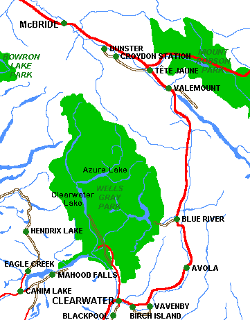 This
trip is in Wells Gray Prov. Park which is in British Columbia just west
of Jasper Provincial Park. The trip to the Azure Lake and Rainbow Falls
takes you 20km up Clearwater Lake, up the Clearwater River and into the
less visited and beautiful Azure Lake. Azure Lake is in the Cariboo
Mountains while Clearwater is more in the foothills. The mountains rise
dramatically out of Azure and many waterfalls drop right into the lake.
It reminded us of Isaac Lake on the Bowron Loop. The Rainbow Falls are
at the far east end of Azure Lake and the camp has a wonderful white
sand beach. This would be a nice place to spend an extra day if you have
time.
This
trip is in Wells Gray Prov. Park which is in British Columbia just west
of Jasper Provincial Park. The trip to the Azure Lake and Rainbow Falls
takes you 20km up Clearwater Lake, up the Clearwater River and into the
less visited and beautiful Azure Lake. Azure Lake is in the Cariboo
Mountains while Clearwater is more in the foothills. The mountains rise
dramatically out of Azure and many waterfalls drop right into the lake.
It reminded us of Isaac Lake on the Bowron Loop. The Rainbow Falls are
at the far east end of Azure Lake and the camp has a wonderful white
sand beach. This would be a nice place to spend an extra day if you have
time.  We
made this trip in late August, 23-30. It is a 116km circuit to the west
of Jasper National Park in British Columbia. The circuit is
world-famous among canoers. The circuit is generally done in 5-8 days,
and we took 8. It features mostly lake paddling with a few easy portages
between lakes; however, it does have one river section on the Cariboo
River. It has one class II rapid, but that can be portaged around (in
fact you have to go out of your way to run the rapid). This is
classified as a wilderness route, but I would put wilderness in quotes.
Unless you go in late-fall or early-spring, you will see people every
day. All the campsites are designated and are developed with fire rings,
tent platforms and pit toilets. Some sites have cooking structures and
on each big lake there is at least one public cabin for drying out and
such.
We
made this trip in late August, 23-30. It is a 116km circuit to the west
of Jasper National Park in British Columbia. The circuit is
world-famous among canoers. The circuit is generally done in 5-8 days,
and we took 8. It features mostly lake paddling with a few easy portages
between lakes; however, it does have one river section on the Cariboo
River. It has one class II rapid, but that can be portaged around (in
fact you have to go out of your way to run the rapid). This is
classified as a wilderness route, but I would put wilderness in quotes.
Unless you go in late-fall or early-spring, you will see people every
day. All the campsites are designated and are developed with fire rings,
tent platforms and pit toilets. Some sites have cooking structures and
on each big lake there is at least one public cabin for drying out and
such.